i. Abstract
This document provides an overview of the Unified Geo-data Reference Model for Law Enforcement and Public Safety (Unified Model). The Unified Model was originally developed by the GIS Center for Security (GIS CS), Abu Dhabi Police. The GIS CS was initiated based on a UAE Ministry of Interior issued decree to establish GIS CS with the core mission: “To geo-enable police services and applications using International standards and best practices.” In 2010, the GIS SC initiated a program to develop a Standardized GIS Environment (SGA). Part of this effort was to define and implement a standard data model for sharing Law Enforcement and Public Safety data.

The above diagram provides a simple architecture view of the UAE SGA. The Unified Model documented in this Best Practice is a key component of the operational SGA. The Unified Model was the result of a focused effort to consider the content and semantics of 18 different geospatially enabled law enforcement and public safety databases in the Emirates that had little overlap in terms of element names and semantics.
ii. Keywords
Ogcdoc, ogc documents, law enforcement, public safety, model, bp
iii. Submitters
All questions regarding this submission should be directed to the editor or the submitters:
| Name | Representing | OGC member |
|---|---|---|
| Maj. Al Mansoori | Chair LEAPS DWG | Yes |
| Richard Smith | ESIS LLC | Yes |
| Ms. Jennifer Harne | Lockheed Martin | Yes |
| Dr. Carl Reed | OGC | Yes |
| Vinod Oommen Ninan | Rolta | Yes |
iv. Foreword
The Unified Geo-data Reference Model for Law Enforcement and Public Safety Request for Comment (RFC) ran from 21 May 2014 to 31 Aug 2014. The model was approved as an OGC Best Practice December 2014.
Attention is drawn to the possibility that some of the elements of this document may be the subject of patent rights. Open Geospatial Consortium shall not be held responsible for identifying any or all such patent rights.
Recipients of this document are requested to submit, with their comments, notification of any relevant patent claims or other intellectual property rights of which they may be aware that might be infringed by any implementation of the specification set forth in this document, and to provide supporting documentation.
Introduction
Open standards are essential if diverse systems are to provide law enforcement, civil security and public safety stakeholders with current and accurate location information that can be accessed and properly understood across organizational boundaries. The Unified Geo-Data Reference Model for Law Enforcement and Public Safety (Unified Model) Services specifies a data modelling framework that can be used to support interoperability at the data and services level.
The Unified LEAPS Model is the result of work undertaken since 2010 within the UAE Ministry of Interior’s Abu Dhabi Police General Headquarters GIS Center for Security (GIS CS). The reference model development effort also included other organizations. While any given Law Enforcement organization will have differences in how it models the real world, there are many aspects of the domain such as incident location that are common across organizations. However, currently there is no data model best practice for the Law Enforcement community to use as a reference for these common information elements. The Reference Model described in the referenced diagrams is provided as an exemplar and a starting point to help facilitate greater commonality and interoperability between organizations. As is common within this law enforcement domain, policing agencies will not utilize any reference model until it has been deemed a best practice. Upon acceptance the expectation is that modifications and enhancements will occur to meet the needs of a wider, more global population.
This best practice is not meant to compete or replace existing standards such as the NIEM (National Information Exchange Model) standard. The NIEM emphasizes data exchange between organizations typically within the US, and is based on XML, which reflects only a small subset of the information of interest to a full data model. The Unified Geo-Data RM utilizes existing OGC standards like WMS and WFS. Geo for LEAPS has been tested for interoperability in OGC Web Services Testbed 10 with a high level of success.
Future Work
This section provides information on planned future work on the model. The content of this section is based on comments received during the OGC public comment and voting period for this Best Practice.
The Unified Geo-Data Reference Model for Law Enforcement and Public Safety (Unified Model) Services is different from other OGC Best Practices. The others are more specific to OGC standards, such as defining profiles of an existing standard. The Unified Geo-Data data model is currently independent of existing OGC standards. The model is aslo currently independent from NIEM, the US National Information Exchange Model. NIEM was initially created to be the Information Exchange Model for US purposes. However uptake and the use of NIEM is increasing in other countries and therefore should be reviewed and considered for future work on the model. The plan is to next consider other, mature interchange models and encodings used in the Law Enforcement and Public Safety communities as well as the OGC and ISO standards baseline. Based on these evaluations, the Unified Model will be evolved to be harmonized with other national and international best practices in these communities.
In the OGC Web Services 10[1] testbed we performed a good deal of testing using the model with considerable success. There is currently only one implementation in production. We need a best practice, which is an official OGC recommendation, to get communities to utilize and implement the model. We hope that there will be more real world implementation examples once the model is published as an OGC best practice. Again please note that the model is not an OGC standard but is a recommendation for use for one very specific domain. NIEM focuses on numerous domains, with Law Enforcement being a small sliver of the NIEM work and model.
Currently the Unified Model does not really fit with any other law enforcement and public safety data models. While there may be overlap, the intent is to not replace any existing standards but just to provide a best practice defining which pieces of these other data models can use. And of course the model will be updated and maintained as we realize what works and what doesn’t. The current Best Practice is the ground floor or starting point of this modelling activity. We believe that harmonization discussions with other standards will occur as the model matures. Regarding the NIEM, while the focus of the NIEM community is related, their work is much more broad reaching in terms of information communities and domains. Further, NIEM work is emphasizing data exchange between many different organizations within the US – many with no public safety or law enforcement remit. As such only a small subset of the information is of interest to a full law enforcement data model.
There is room for maturing and enhancement of the model as we move forward, including harmonization. With no other extensive models in existence for the Law Enforcement community, this is the only best practice model we are aware of and therefore by publishing and communicating the model, hopefully it will get more attention, inputs and have the information necessary to evolve the model.
Business Requirements
The following is a list of key business requirements that drove the development of the Unified Model.
- Avoid duplicity of spatial data storage across different Police business areas
- Establish a single point of reference for Geo-Spatial data for Police businesses
- Establish common standards on the storage of Geo-Spatial data for policing.
- Assign a Geo-referenced address or location for non-spatial data,
- Supports interoperability at the data and services level
- Provision of location based intelligence in support of law enforcement and public safety needs
Guide to Model documents
This section provides a short description of the primary tables defined in the model. There are three major “packages” in the model.
Base Mapping (External Agencies Data)
Police Fixed Assets
Business (Geo-enablement of Operational data)
In addition, there is a very detailed data model dictionary. The purpose is to document a passive dictionary describing the UGSD data model: Data Theme / Model Attribute Groups / Field Names / Data Types / Precision / Scale / Domain Subtype / Values and Descriptions, and so on. Below is an example of the content of the data model dictionary.

Base Mapping (External Agencies Data)
The External Agencies data components of the Unified model detail the tables and elements necessary to exchange non police specific data, such as administrative boundaries, between organizations. These data elements are necessary to complete mandates and objectives for law enforcement and public safety.
Administrative
The Administrative Package contains tables and elements for:
- Boundaries
- Census
- Labor Cities
- Island
Critical Assets 1
The First Critical Assets Package contains tables and elements for:
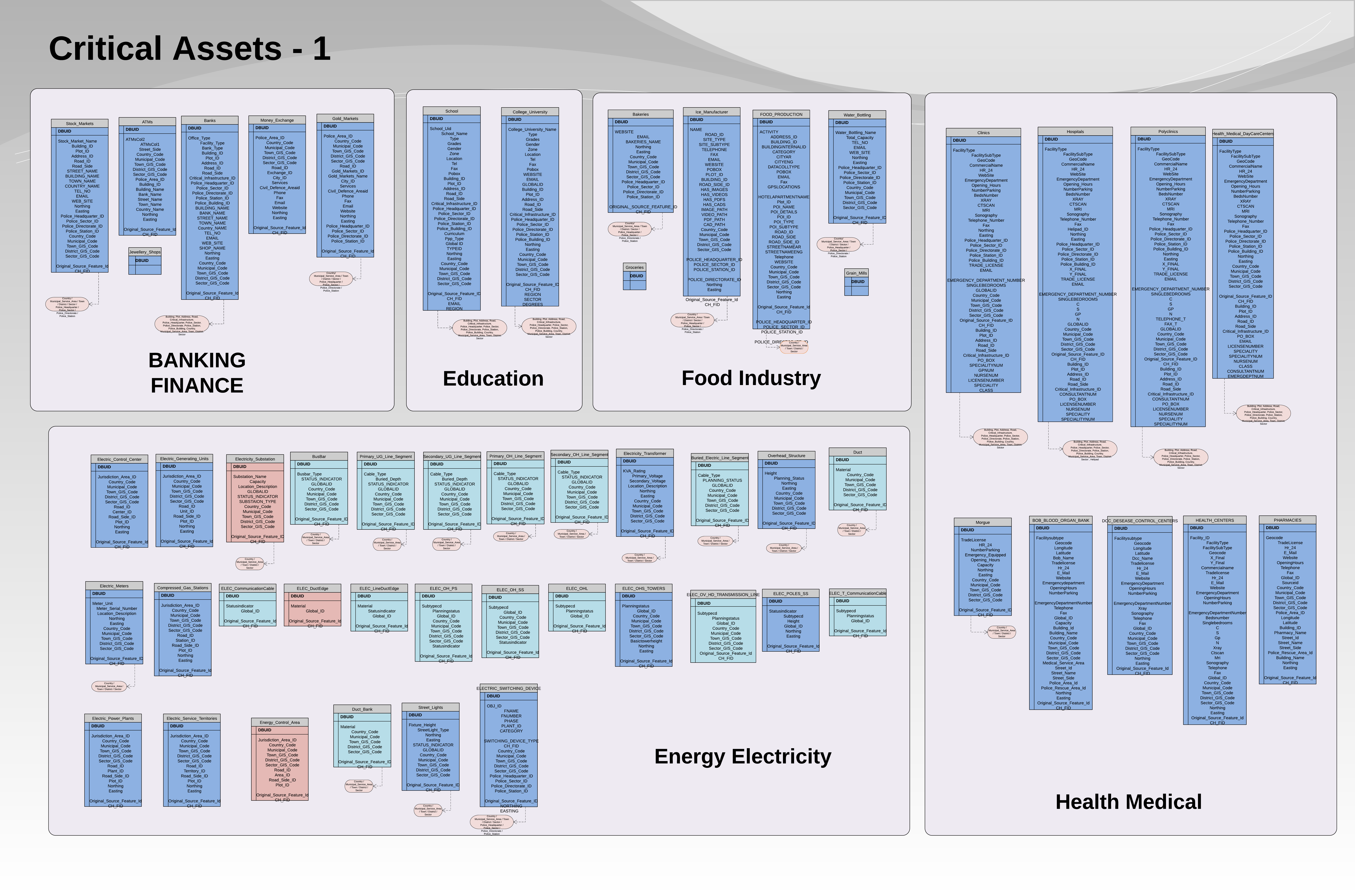
- Banking and Finance
- Education
- Food Industry
- Health and Medical
- Energy – Electricity
Critical Assets 2
The Second Critical Assets Package contains tables and elements for:
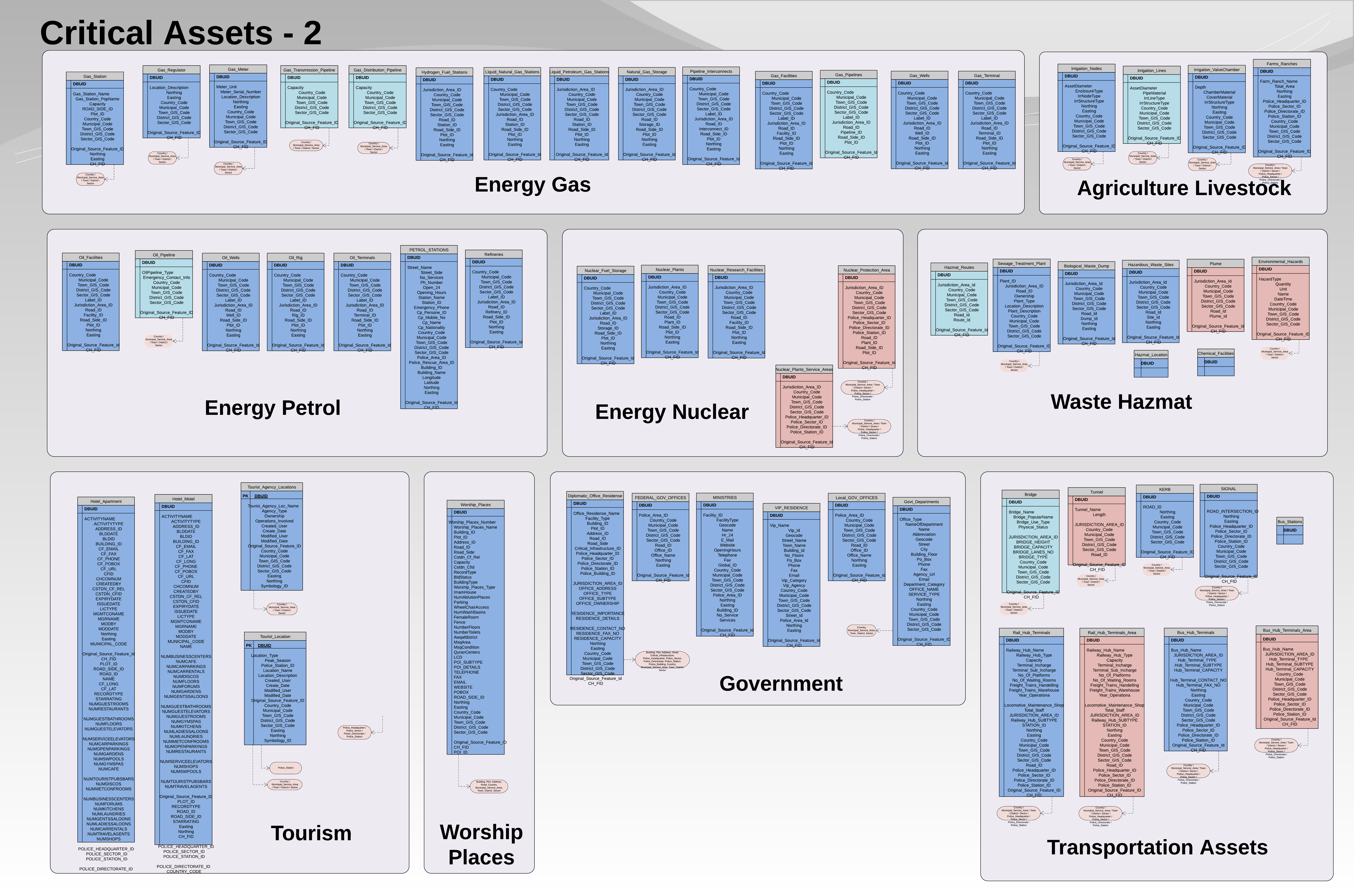
- Energy – Gas
- Energy – Petrol
- Energy – Nuclear
- Agriculture and Livestock
- Waste HAZMAT
- Tourism
- Places of Worship
- Government
- Transportation Assets
Environmental
The Environmental Package contains tables and elements for:
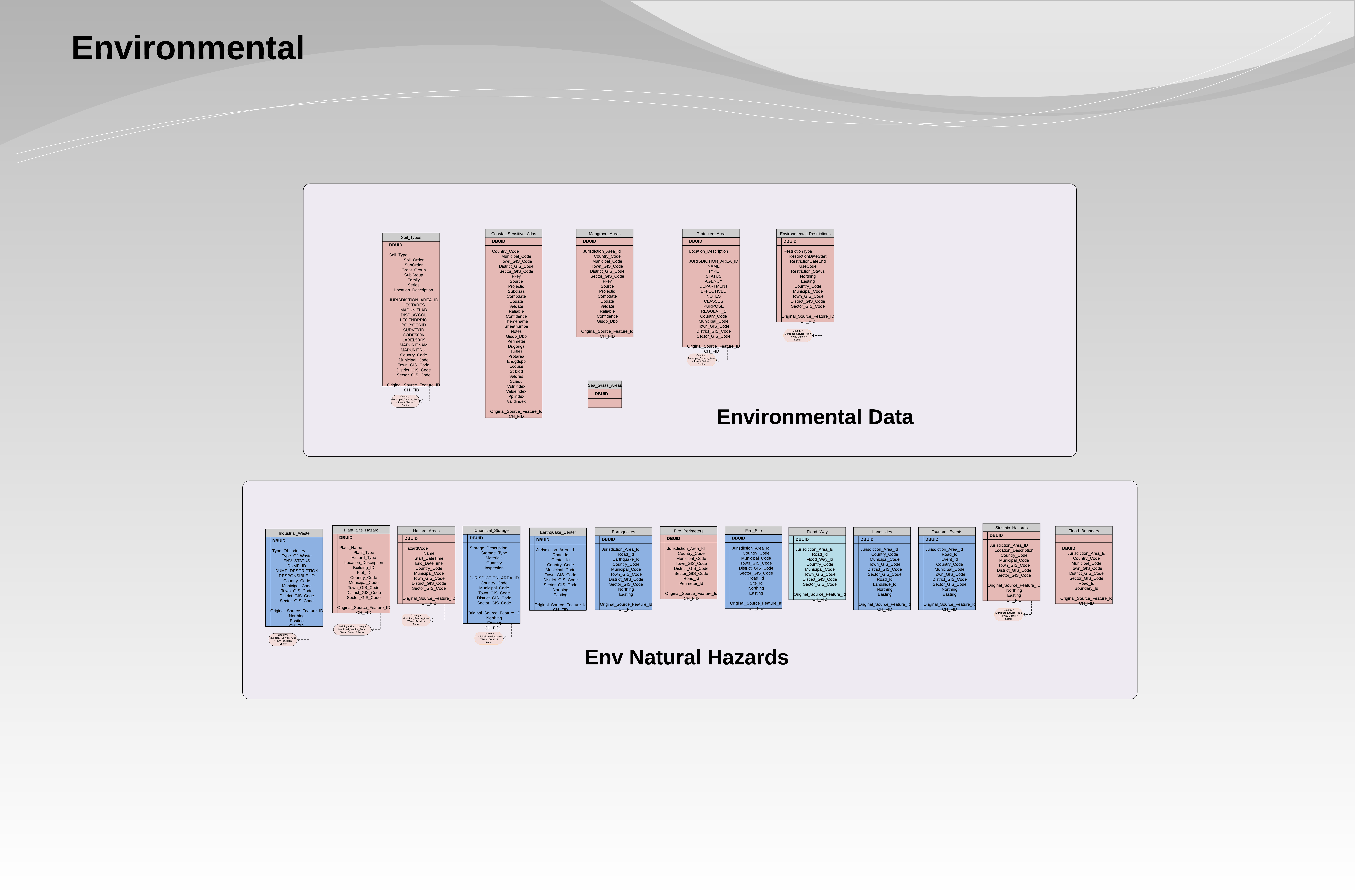
- Environmental Data
- Environmental Natural Hazards
Utilities
The Utilities Package contains tables and elements for:
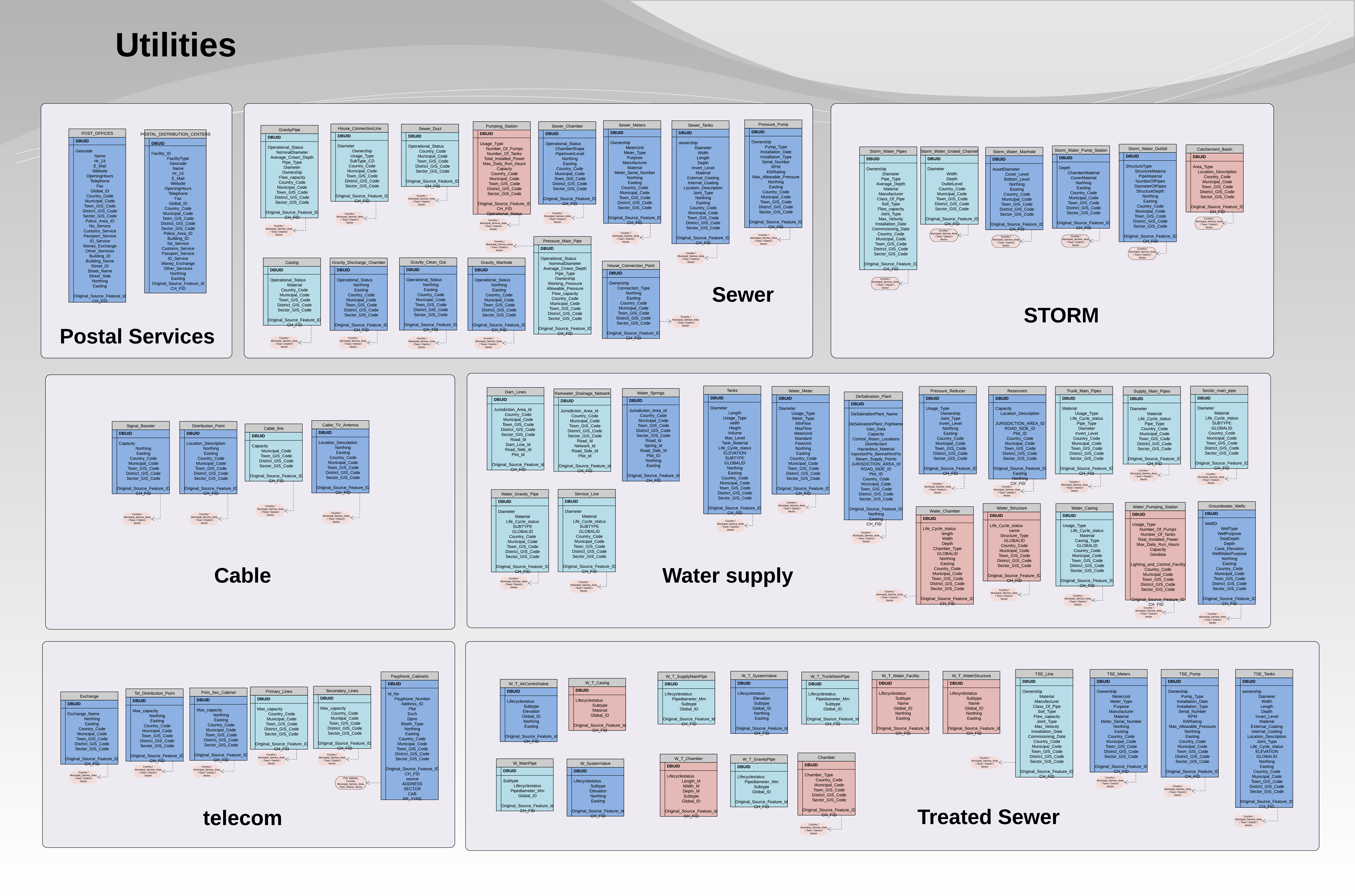
- Postal Services
- Storm
- Sewer
- Cable
- Water Supply
- Telecom
- Treated Sewer
Raster Data
The Raster Package contains tables and elements for:
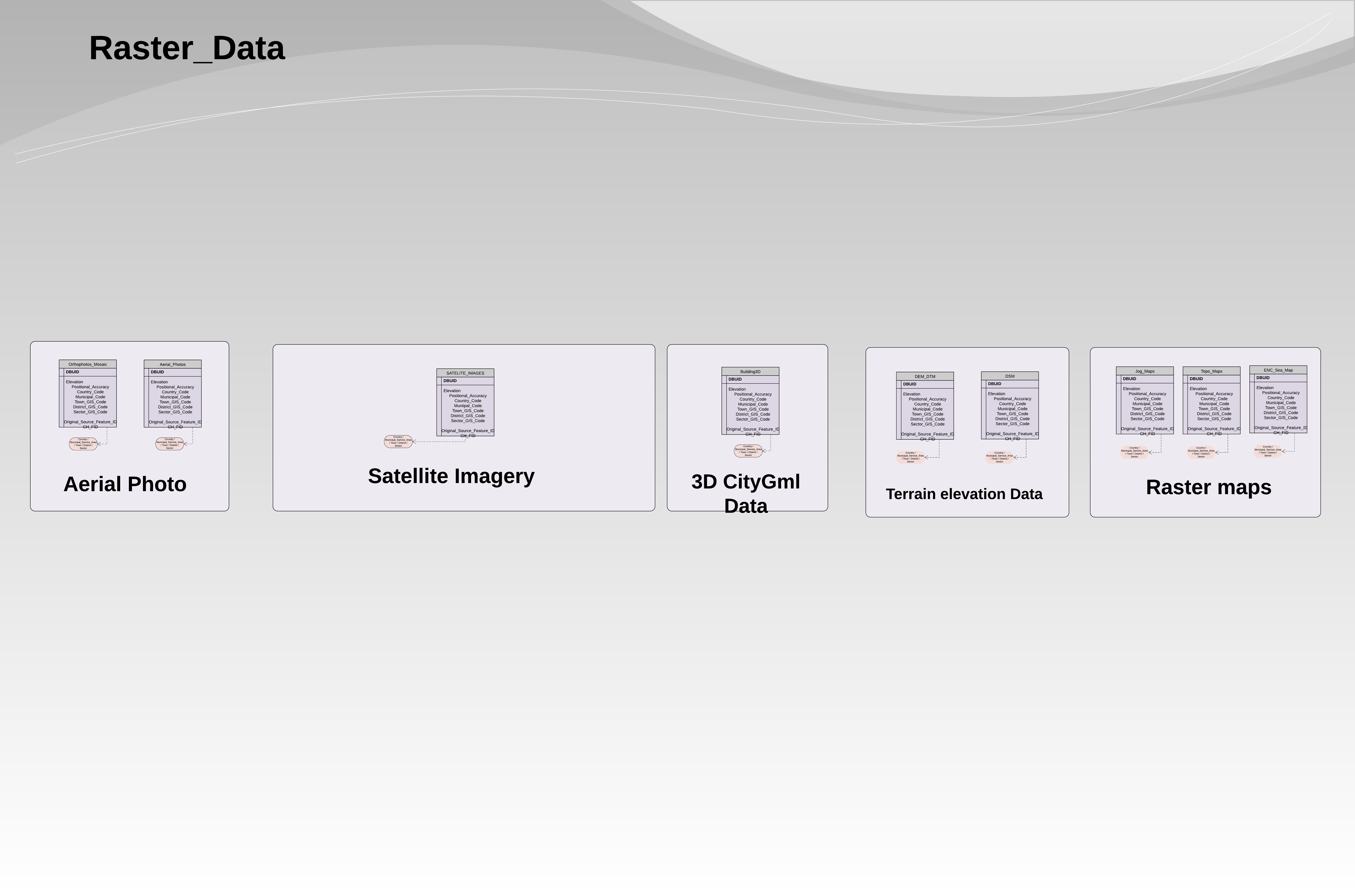
- Satellite imagery
- 3d CityGML
- Aerial Photos
- Terrain Elevation Data
- Other Raster Maps
Municipal Data
The Municipal Data Package contains tables and elements for:
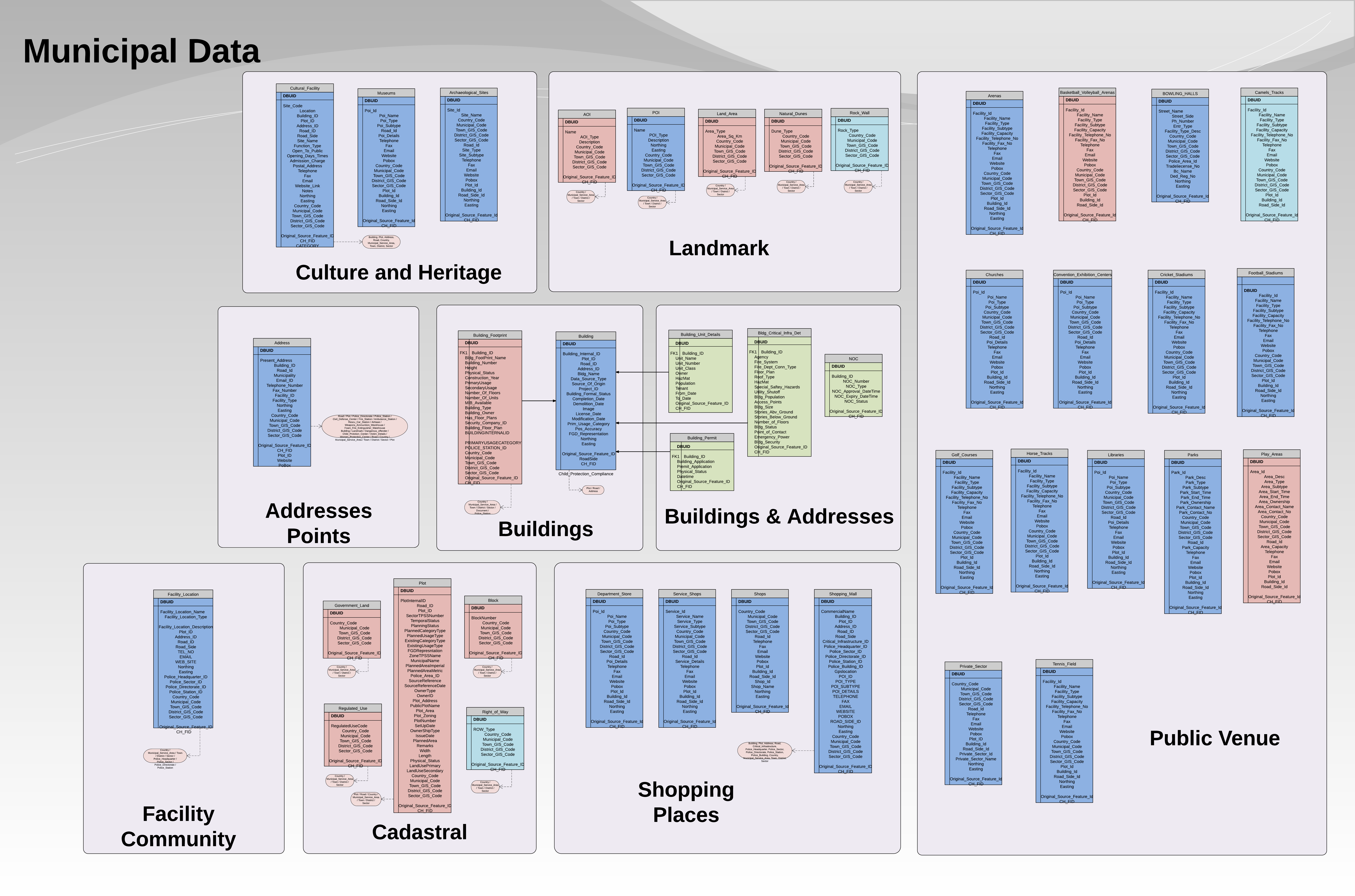
- Culture and Heritage
- Landmarks
- Address Points
- Buildings
- Building Addresses
- Facility – Community
- Cadastral
- Shopping Places
- Public Venue
Vegetation
The Vegetation Package contains tables and elements for:
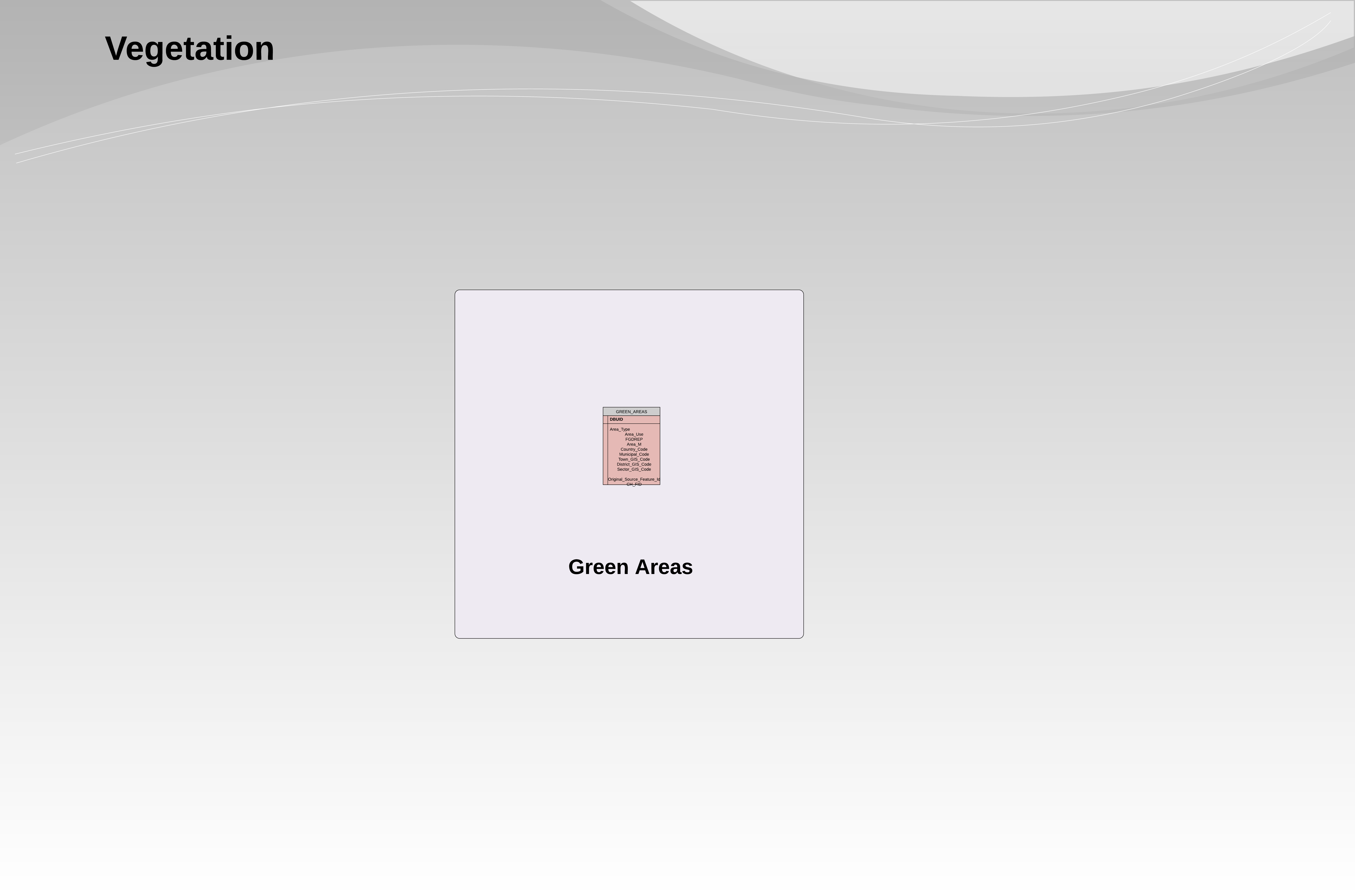
- Green Areas
Water Bodies
The Water Bodies Package contains tables and elements for:
- Natural Water features
Topograhic Data
The Topograhic Data Package contains tables and elements for:
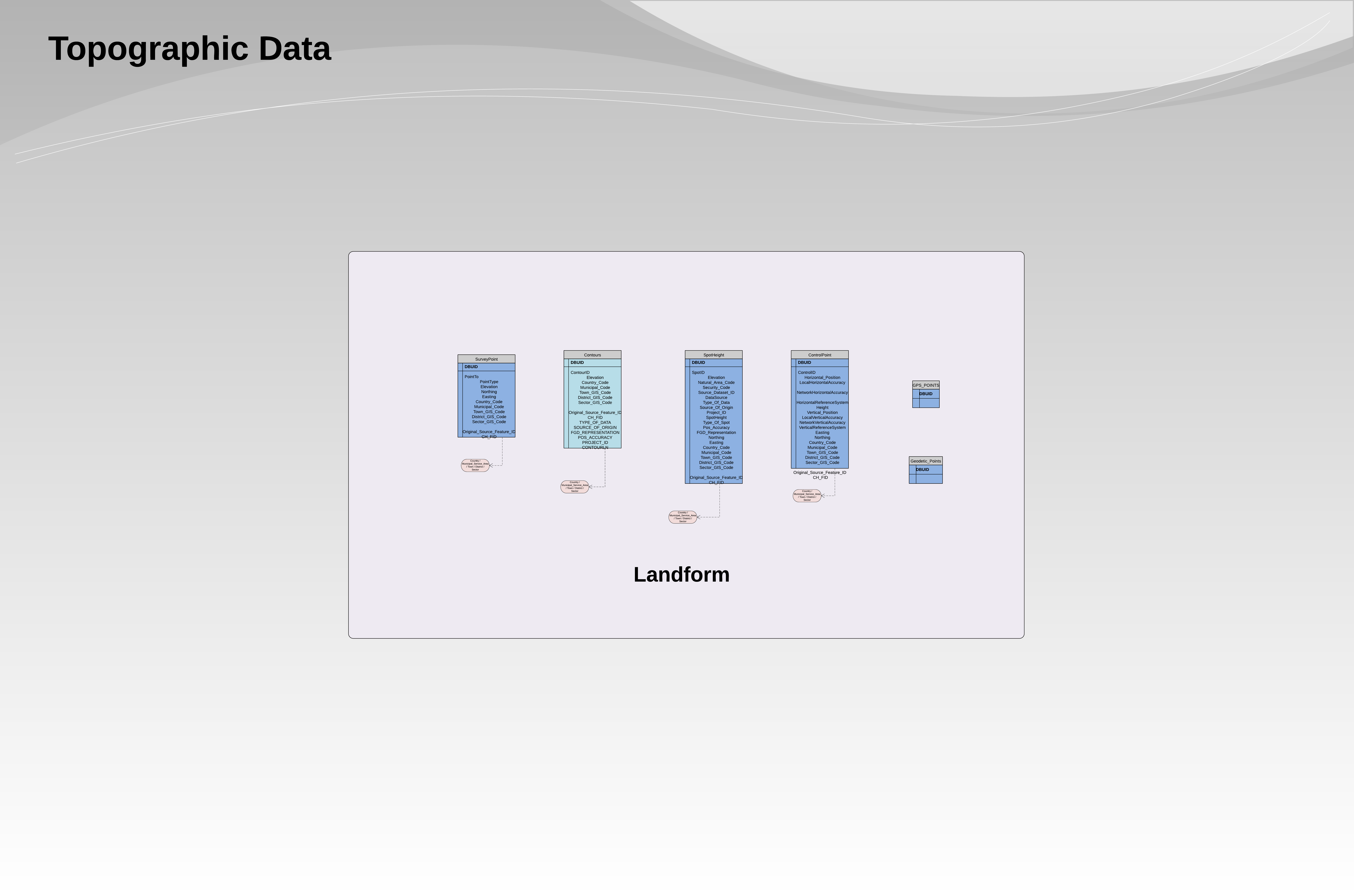
- Survey Point
- Countours
World Map
The World Map Package contains tables and elements for:
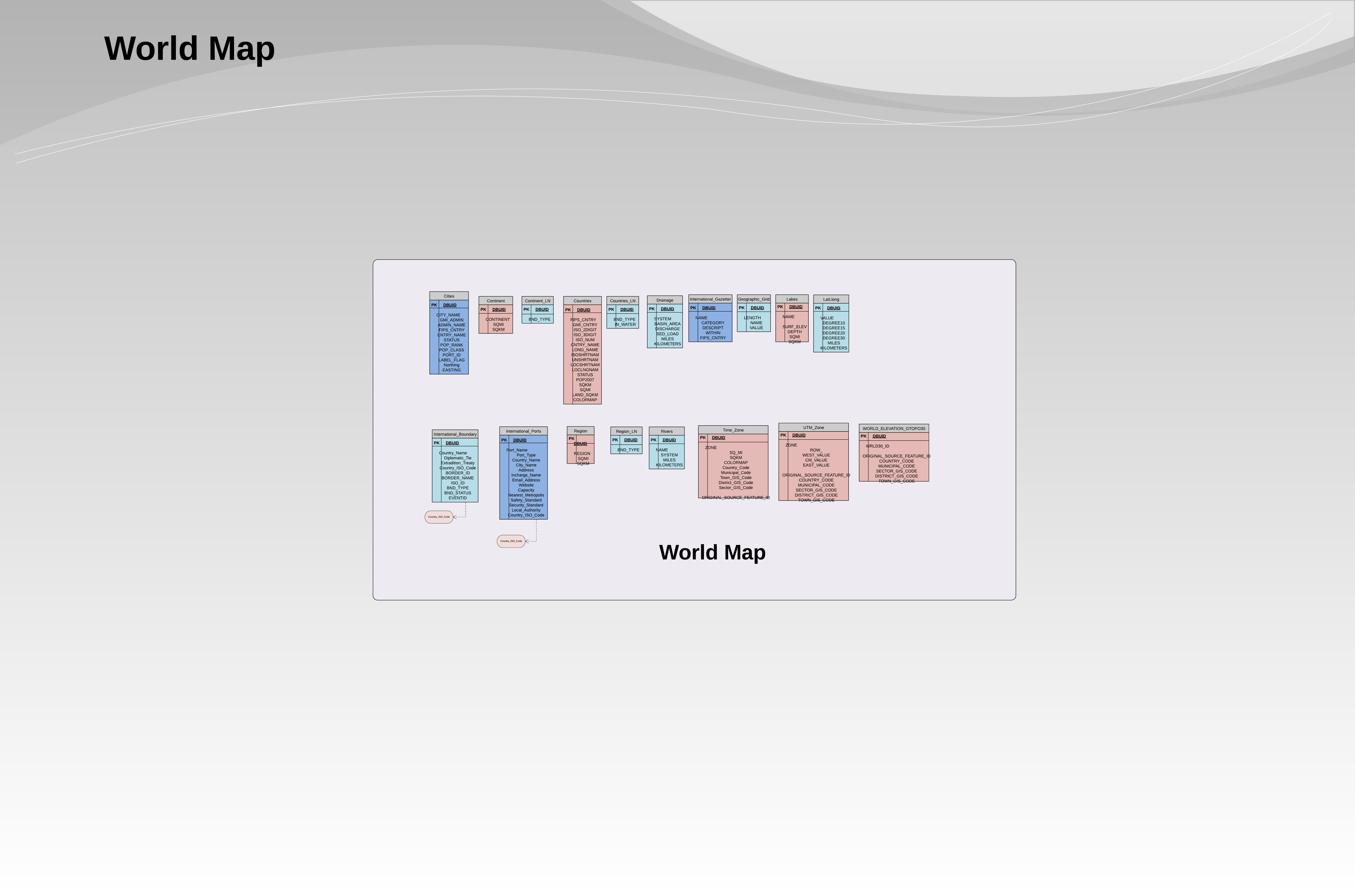
- World Map
Roads Network
The Roads Network Package contains tables and elements for:
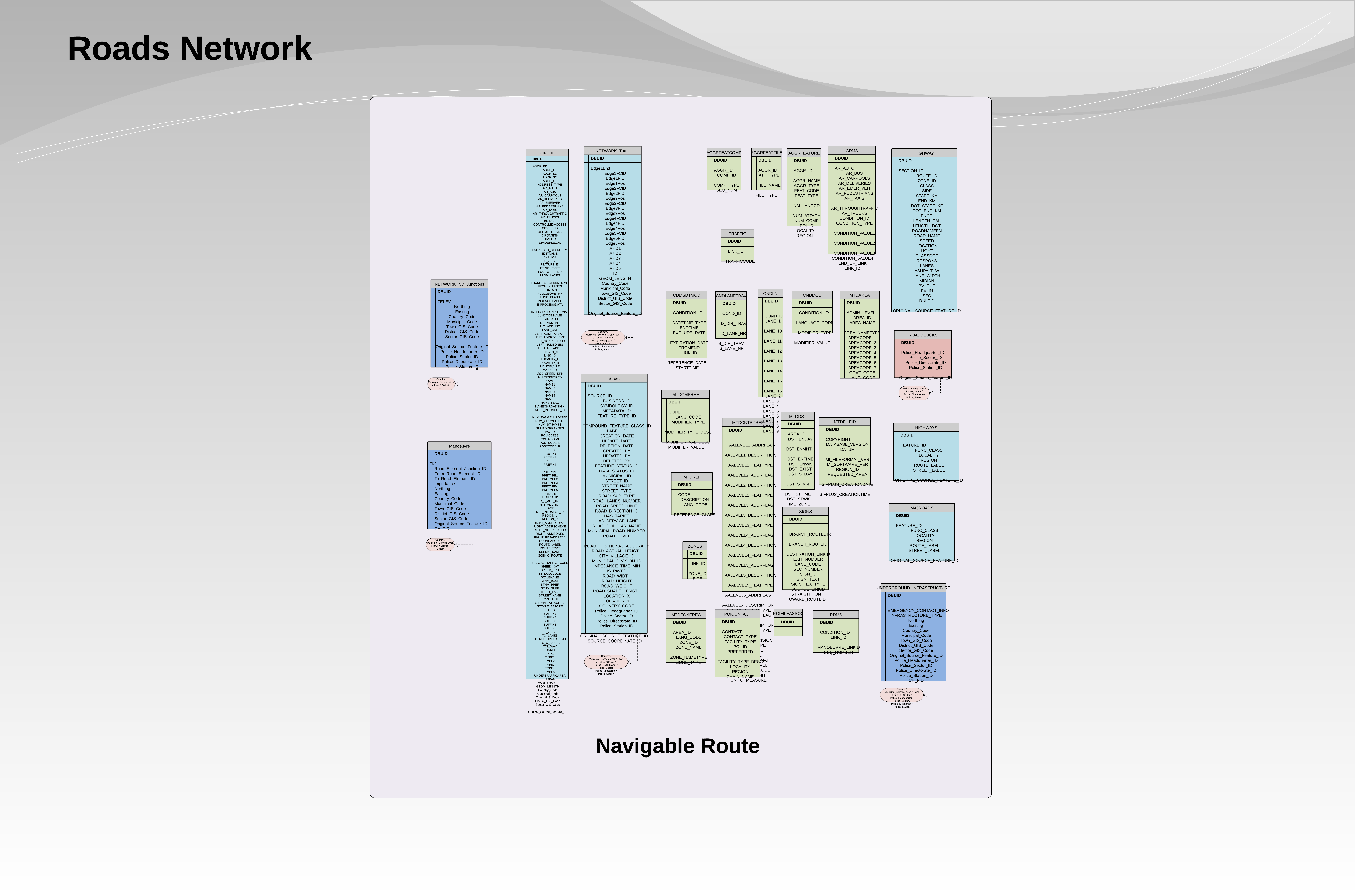
- Navigable Route
Navigation Chart
The Navigation Chart Package contains tables and elements for:
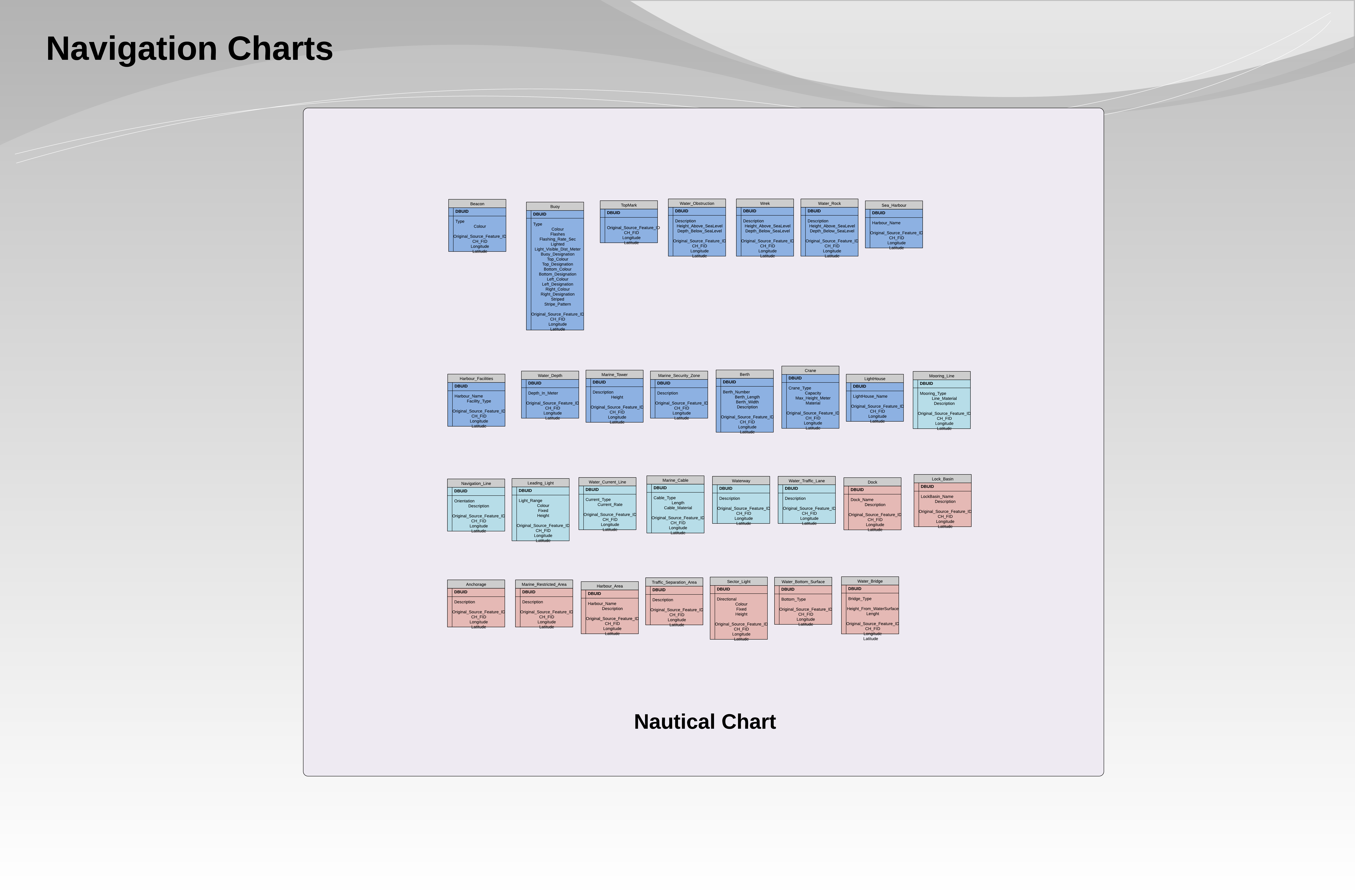
- Nautical Charts
Town Planning
The Town Planning Package contains tables and elements for:
- Master Plan – Urban Development Plan
- Urban Development – Transport Plan
- Urban Development – Public
Transportation
The Transportation Package contains tables and elements for:
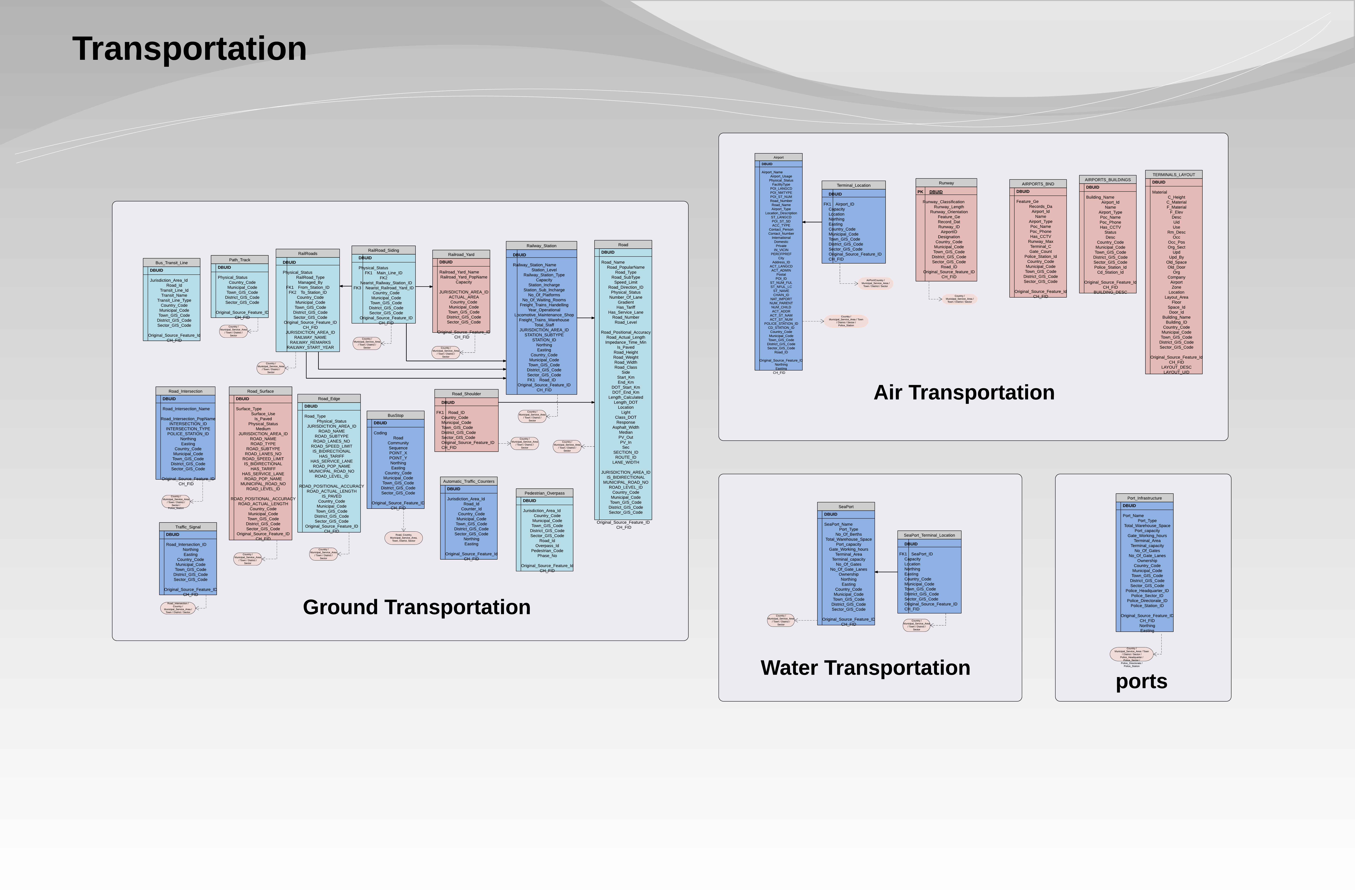
- Ground Transportation
- Air Transportation
- Water Transportation
- Ports
Police Data and Operations Model
The Police Data model defines tables and elements for sharing Law Enforcement, Public safety, internal security, defense and intelligence, national security and police operations data. Each of these table sets is now described.
Law Enforcement
The Law Enforcement package contains tables and elements for:
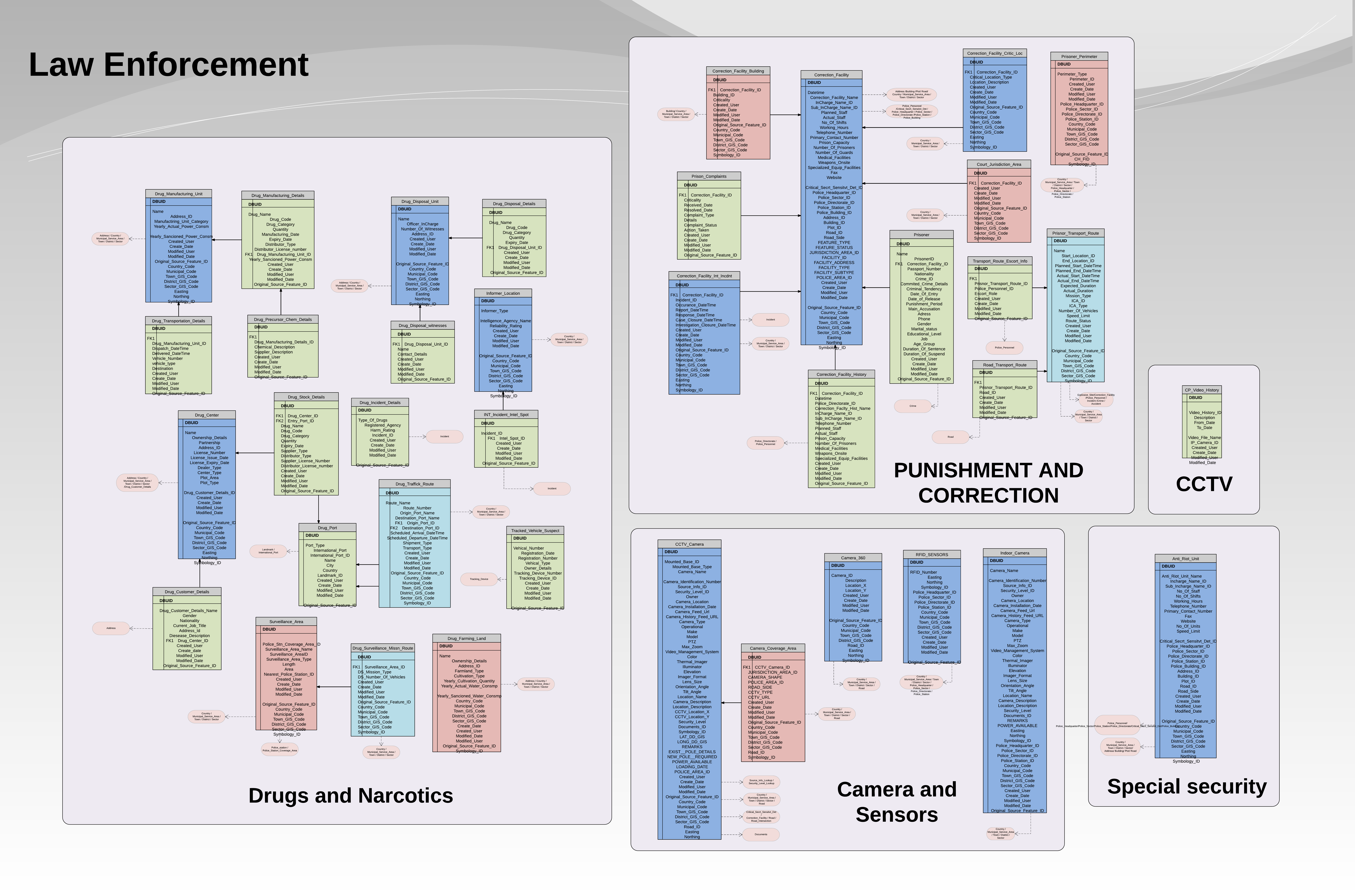
- Drugs and Narcotics
- Sensors and Camera Systems (Entry 12342 in Data Dictionary)
- Punishment and corrections
- Special Security
- CCTV
Public Safety 1
The First Public Safety Package contains tables and elements for:
- Civil Defense
- HAZMAT
- Building Safety Assessment
Public Safety 2
The Second Public Safety Package contains tables and elements for:
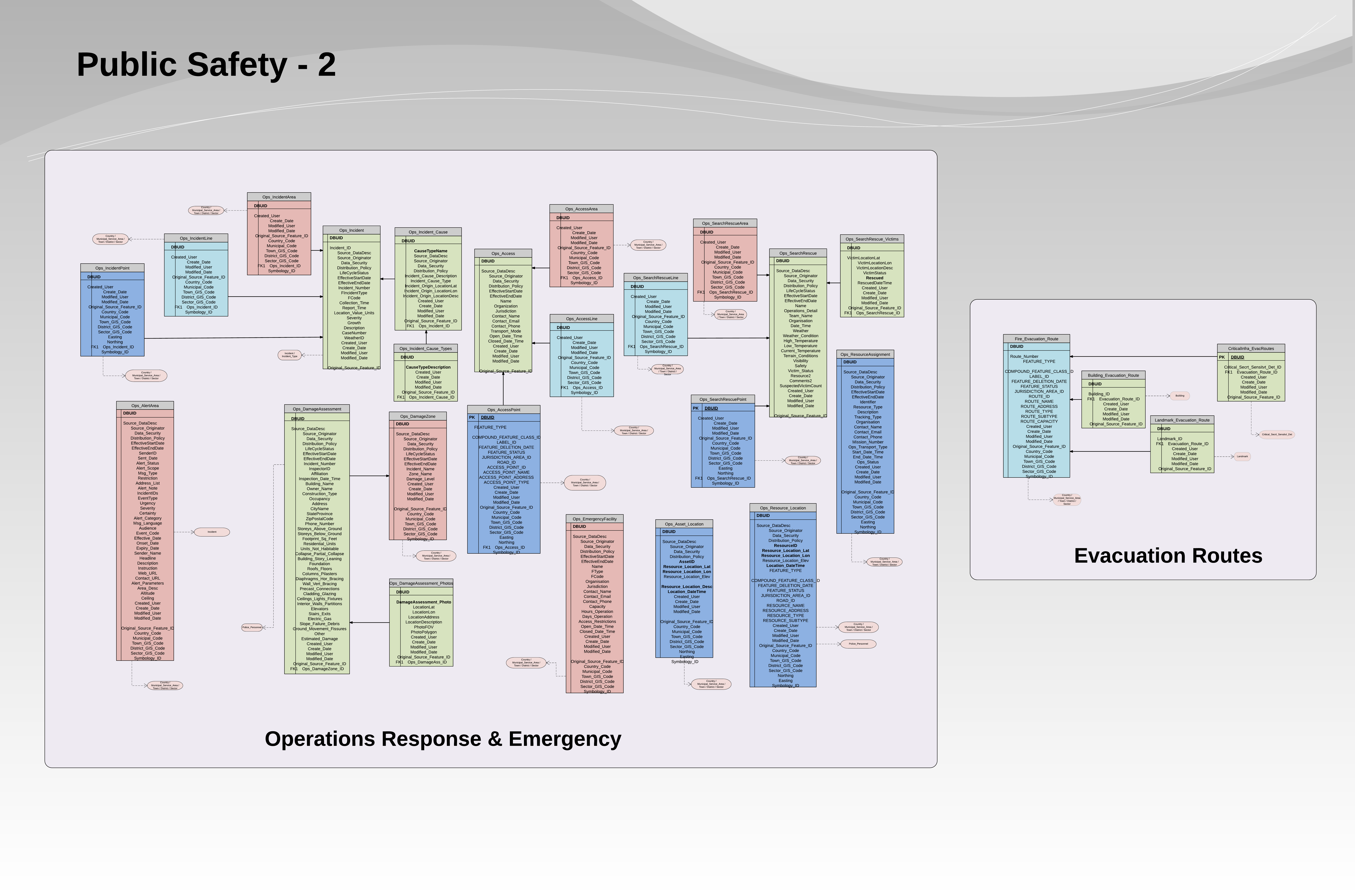
- Operations Response and Emergency
- Evacuation Routes
Internal Security 1
The First Internal Security Package contains tables and elements for:
- Social Services
- Security – Preventive
- Community Police
- Community Service
Internal Security 2
The Second Internal Security Package contains tables and elements for:
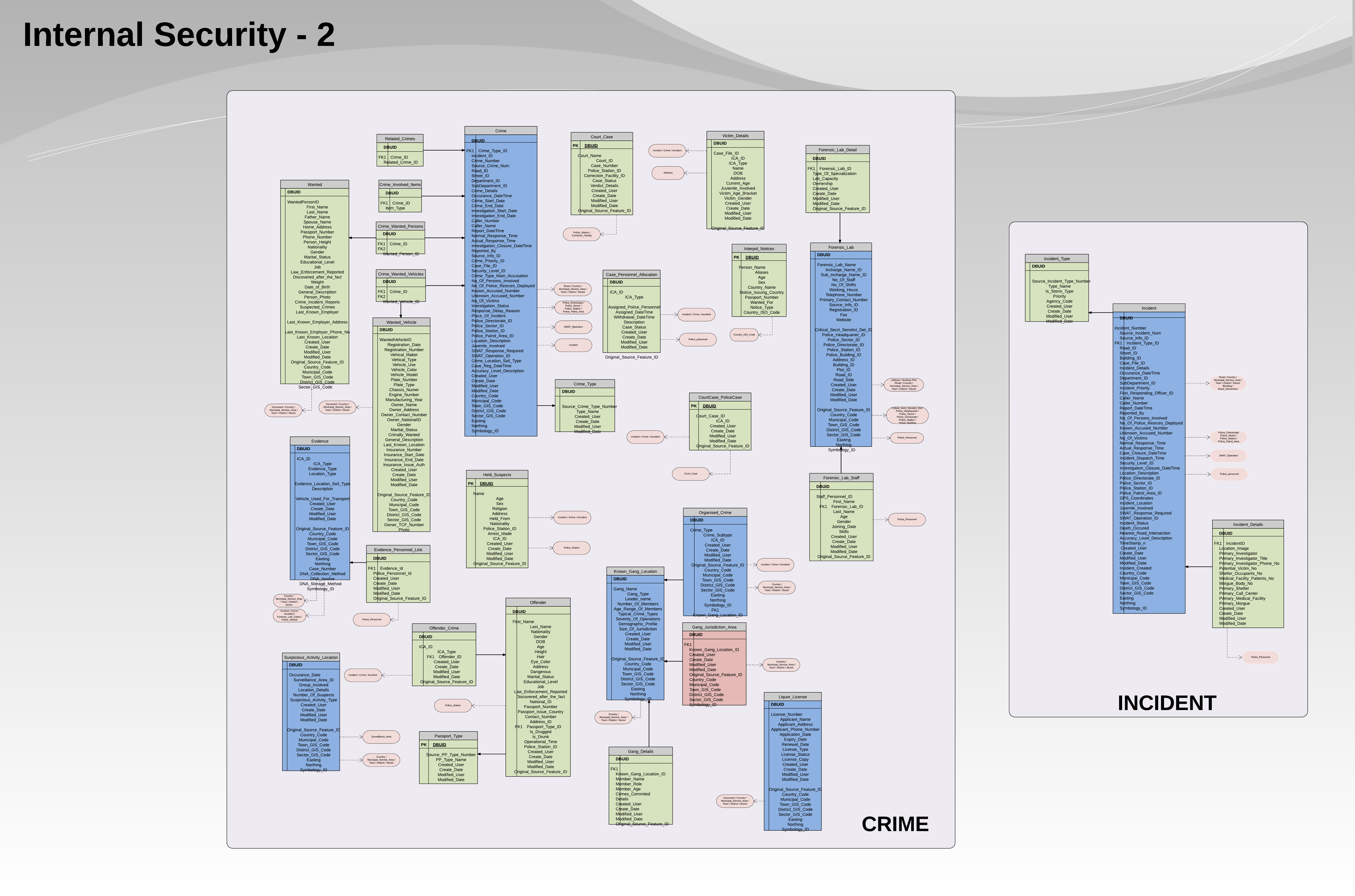
- Crime
- Incident
Internal Security 3
The Third Internal Security Package contains tables and elements for:
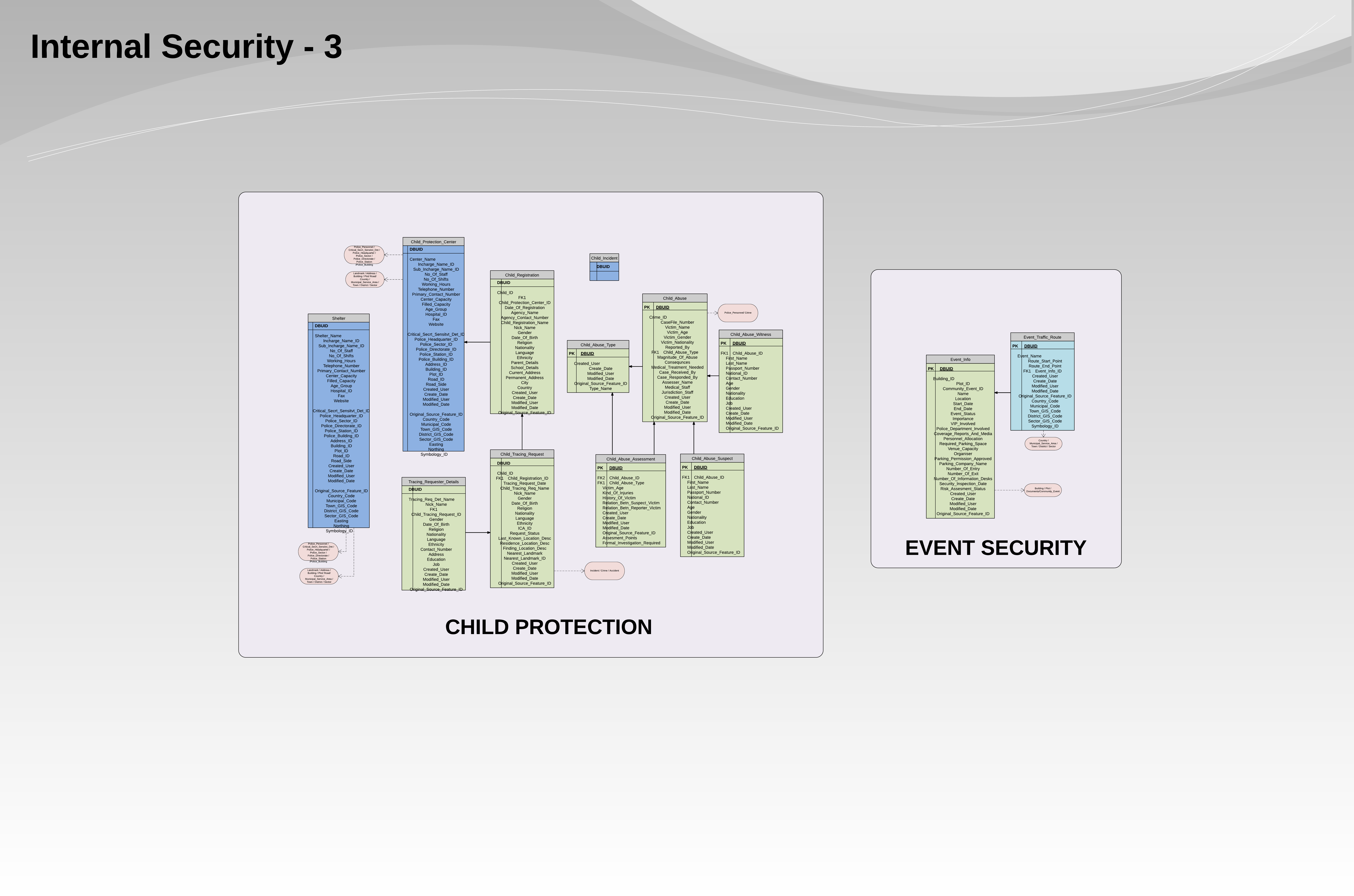
- Child Protection
- Event Security
Internal Security 4
The Forth Internal Security Package contains tables and elements for:
- Traffic
National Security
The National Security Package contains tables and elements for:
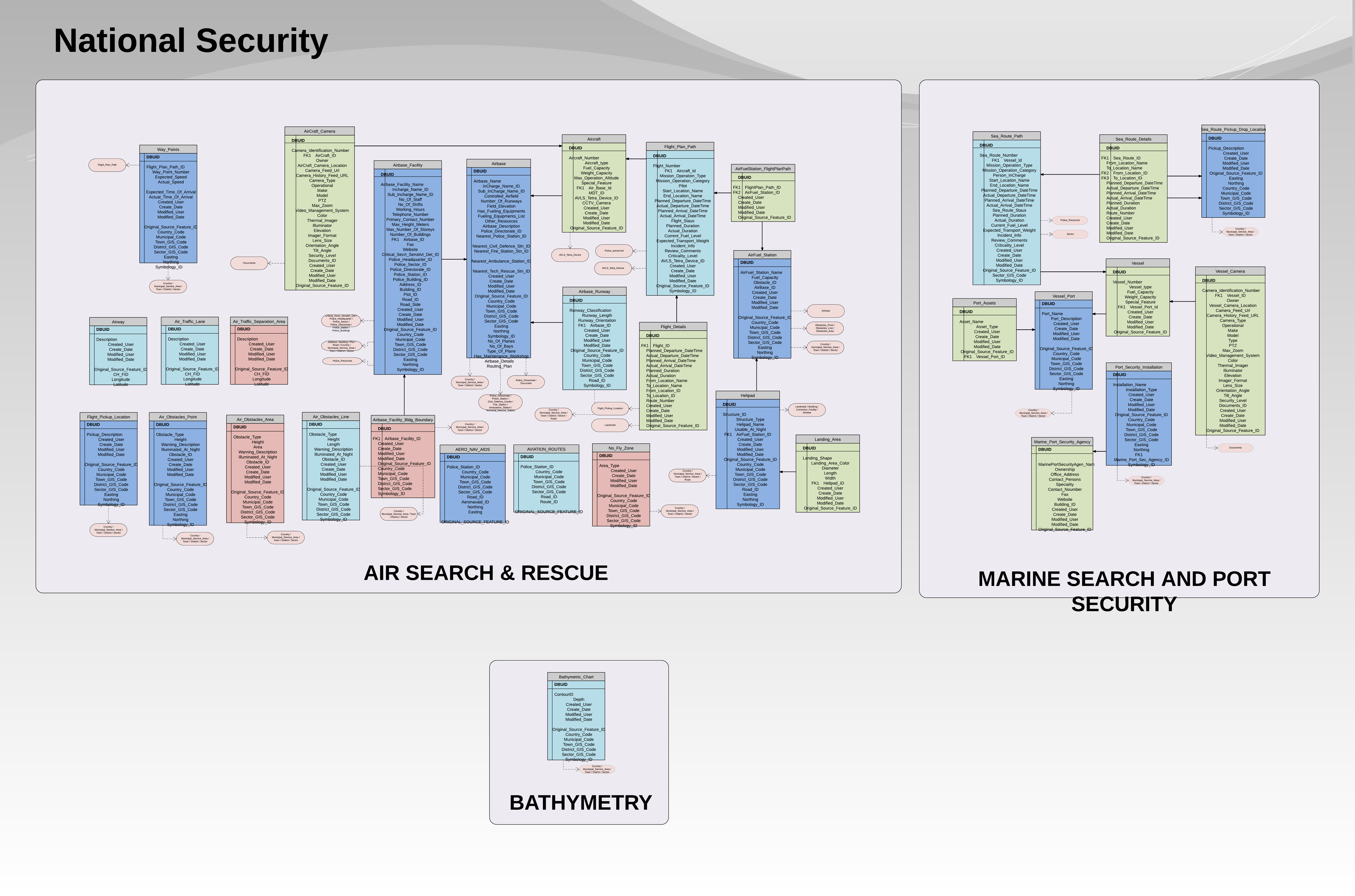
- Air Search and rescue
- Marine Rescue and Port Security
- Bathymetry
Defence and Intelligence
The Defence and Intelligence Package contains tables and elements for:
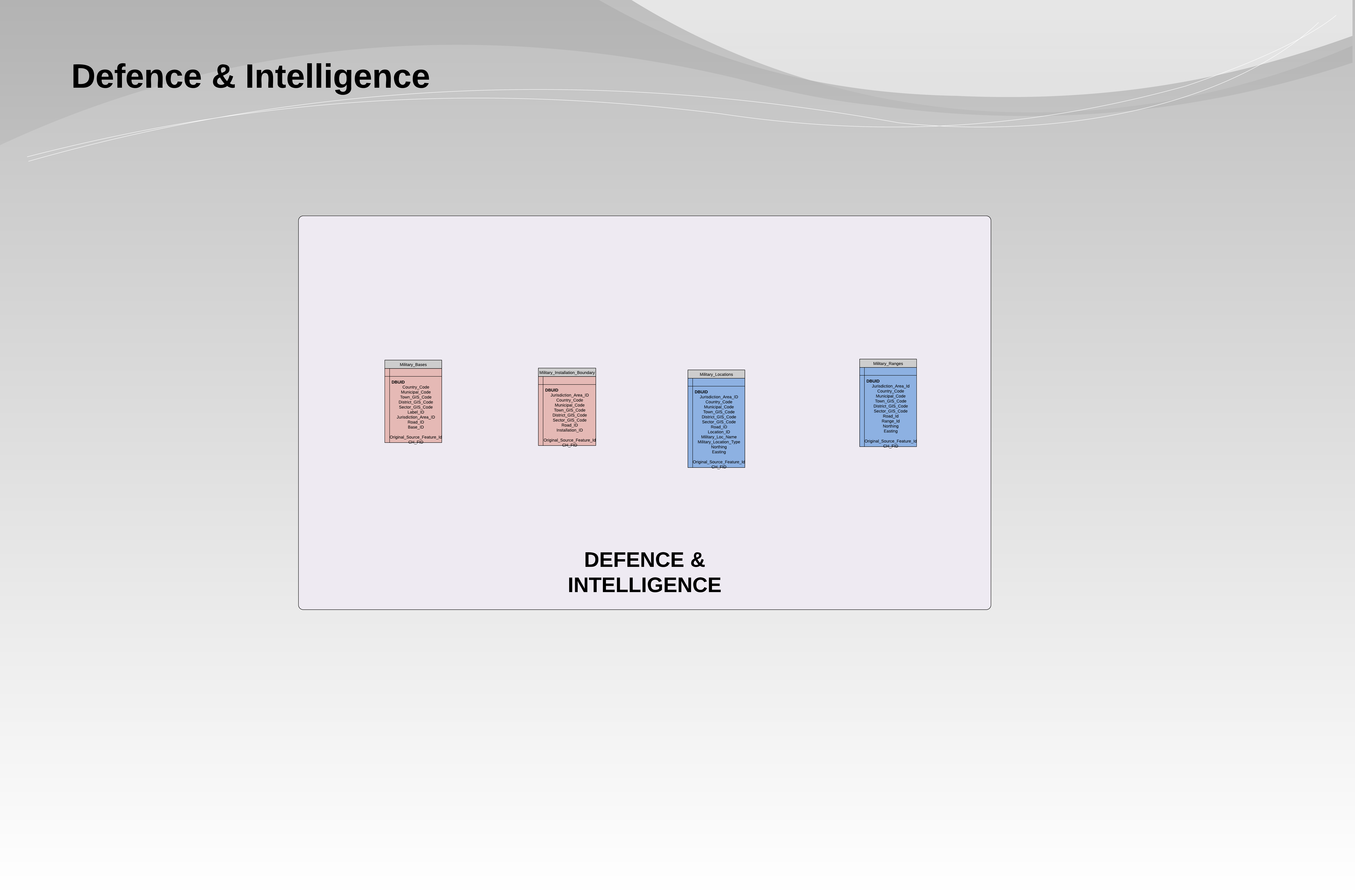
- Defense and Intelligence
Police Operations 1
The First Police Operations Package contains tables and elements for:
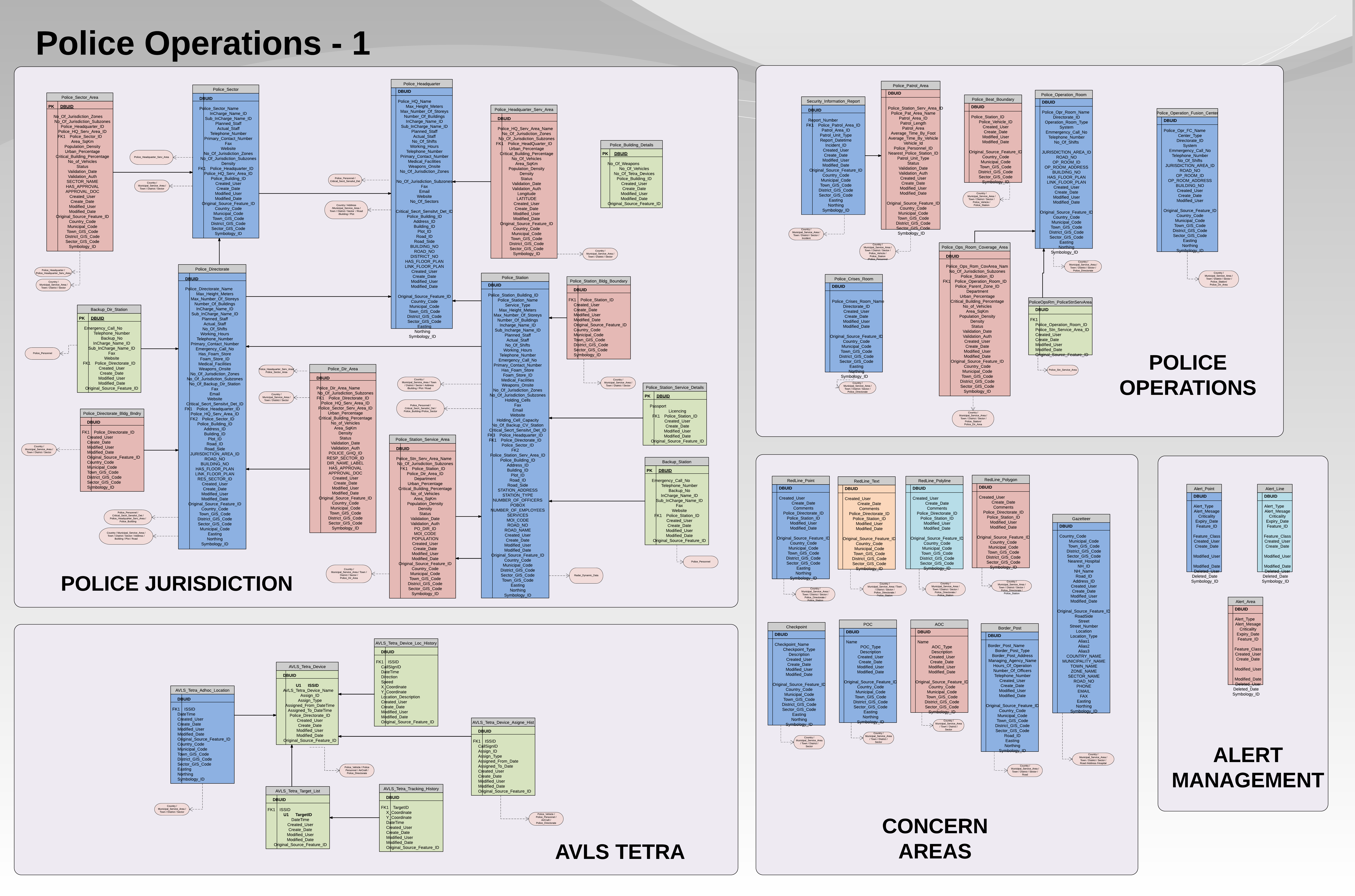
- Police Jurisdiction
- AVLS Tetra
- Concern Areas
- Police Operations
- Alert Management
Police Operations 2
The Second police Operations Package contains tables and elements for:
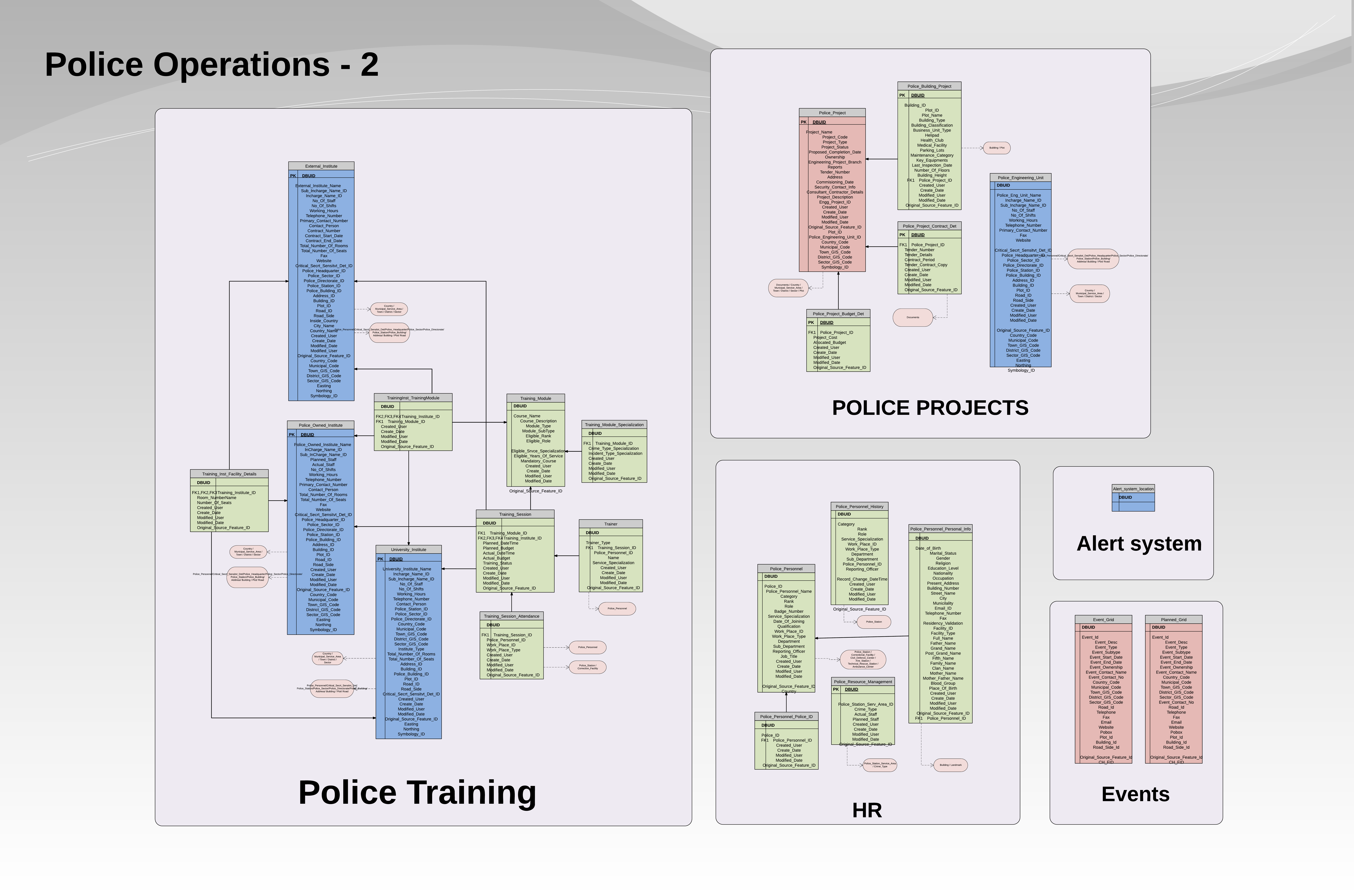
- Police Training
- HR
- Police Projects
- Alert System
- Events
Police Operations 3
The Third Police Operations Package contains tables and elements for:
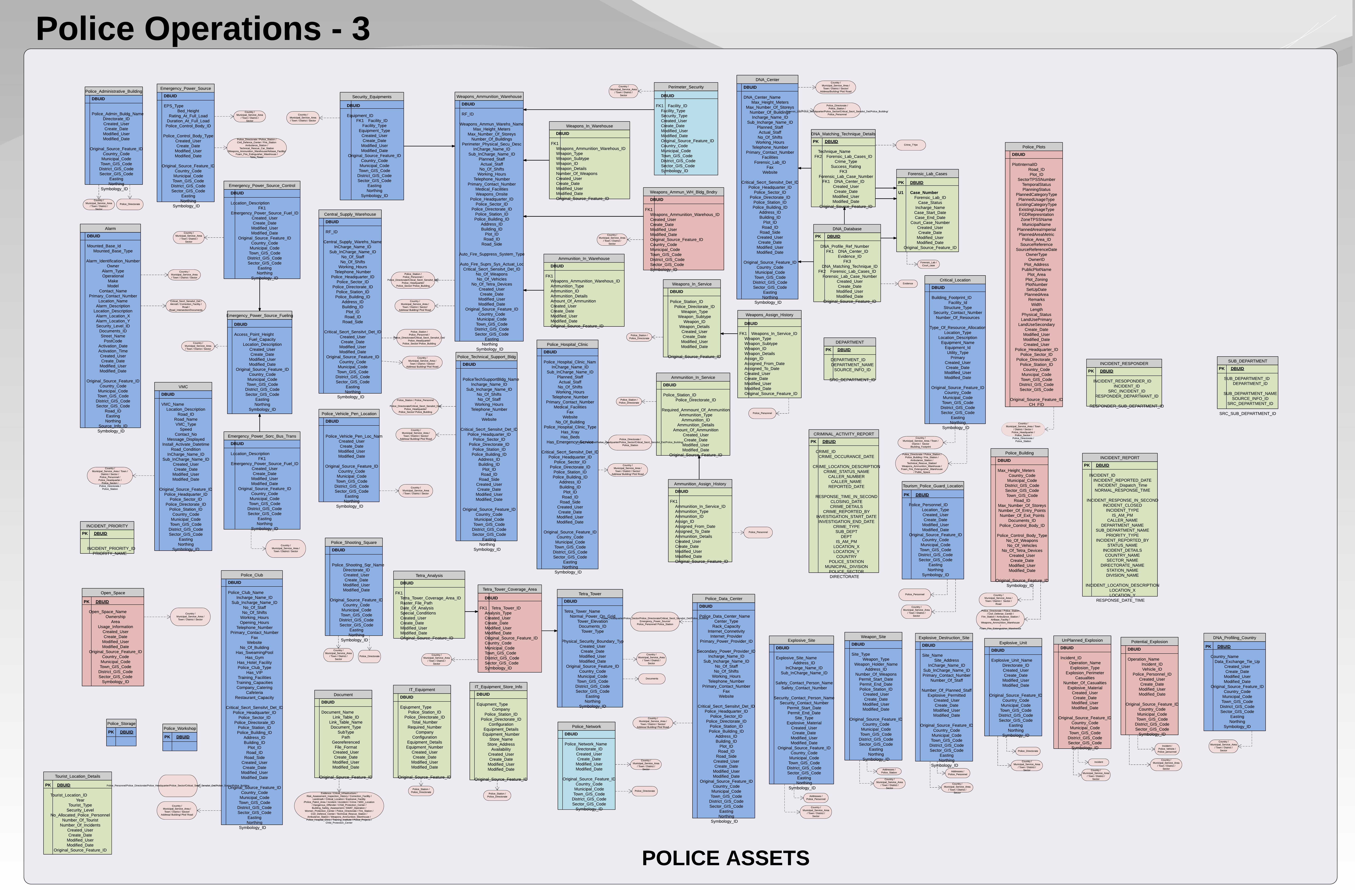
- Police Assets
[1] OGC® Testbed 10 Cross Community Interoperability (CCI) Ontology Engineering Report: https://portal.opengeospatial.org/files/?artifact_id=58974